The ArcGIS Enterprise 11.5 release includes a range of improved image management and analysis features designed to make imagery easier to access at scale and extract meaningful insights. Key features include support for tools in ArcGIS Enterprise on Kubernetes. Its cloud-native architecture provides valuable scalability and ensures platform parity for a consistent experience across ArcGIS. New raster analysis and AI functionality in ArcGIS Excalibur, a focused imagery app, further automates image and video analysis. Enhanced support for new data types, such as video and oriented imagery, expand the platform’s capabilities.
Key Features:
Scalability and Platform Parity
- Support for custom Python raster functions in ArcGIS Enterprise for Kubernetes
- Deep Learning Studio in ArcGIS Enterprise for Kubernetes
- Commercial imagery from Content Store for ArcGIS
New Analysis and AI Functionality in Excalibur
- New raster function, deep learning, and video analysis tools
Expanded Support for Motion Imagery and Oriented Imagery
- Streamlined publishing, cloud integrations, and a new tool to create video clips in ArcGIS Video Server
- Support for vector data and 3D layers in Oriented Imagery
Scalability and Platform Parity
With the 11.5 release, ArcGIS Enterprise introduces pivotal features that emphasize scalability for efficient data management and platform parity for consistent image capabilities across ArcGIS. Read on to learn more about the value each new feature brings to customers.
Support for custom Python raster functions in ArcGIS Enterprise for Kubernetes
Python raster functions are custom scripts that can be used to process and analyze raster data within ArcGIS. These functions allow users to more easily perform complex image processing tasks and integrate the processed imagery into workflows, thus making raster data easier to access. Users can bring their own custom algorithms or intellectual property to code their own raster functions, which can then be combined with over 160 out-of-the-box raster functions in ArcGIS to achieve a variety of workflows. With ArcGIS Enterprise 11.5, Python raster functions will now be supported in ArcGIS Enterprise on Kubernetes-based raster analytics. This means organizations can deploy their own image processing models at scale, leveraging containerized environments for high performance and flexibility.

Deep Learning Studio in ArcGIS Enterprise for Kubernetes
Deep Learning Studio, the collaborative deep learning web application on ArcGIS Enterprise that helps users prepare training data, train models, and run inference, is expanding its reach. Previously available only on Windows and Linux deployments, it will now be supported on ArcGIS Enterprise 11.5 for Kubernetes.

This empowers organizations to take full advantage of ArcGIS Enterprise for Kubernetes’ scalability, resilience, and cloud-native architecture for large-scale deep learning workflows. With this enhancement, teams can seamlessly scale inference, and data management processes across distributed environments—accelerating imagery-driven AI projects like never before.


Commercial imagery from Content Store for ArcGIS
Content Store for ArcGIS was introduced in February 2025, enabling users to find premium imagery from multiple commercial providers, purchase it, and publish it to their ArcGIS Online organizations. Now, users who purchase imagery from Content Store can also publish it as a Tiled Imagery Layer or TileCache within their organization’s ArcGIS Enterprise environment. Premium imagery is especially valuable for projects that require specific types of imagery, high resolutions, or unique perspectives of areas of interest. This capability facilitates seamless integration of commercial imagery between ArcGIS Online and ArcGIS Enterprise, allowing more users to leverage purchased imagery in their projects. It is particularly useful for projects needing precise, current data, such as urban development, environmental monitoring, and disaster response planning. Learn more about Content Store for ArcGIS in this blog article.

New Analysis and AI Functionality in ArcGIS Excalibur
ArcGIS Excalibur is a focused web-based imagery and video analysis app that now supports raster functions, new deep learning AI tools, and media layers to enable users to extract more insight from imagery and video.
New raster function, deep learning, and video analysis tools
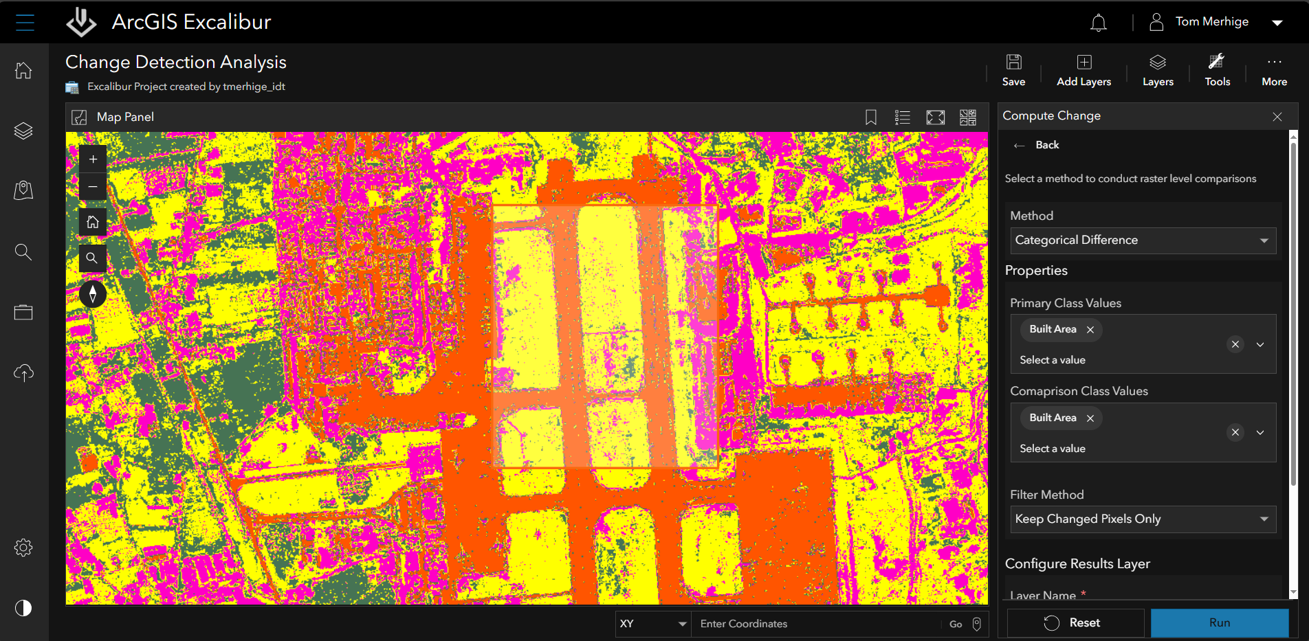
- Get more precise insights with raster analysis: With the ArcGIS Enterprise 11.5 release, ArcGIS Excalibur will support raster functions to empower users to handle complex imagery and video data more efficiently to solve problems. The NDVI Raster Function monitors vegetation health by generating images that display greenness, aiding in resource management and environmental tracking. The Compute Change Raster Function performs advanced server-side change detection, calculating and visualizing differences between two raster datasets in absolute, relative, or spectral terms. Lastly, the Clip Raster Function allows users to extract specific areas from large raster datasets and video footage, reducing loading times and enhancing analysis precision.


- Quickly detect changes with deep learning tools: With the new Deep Learning tool, users can now leverage out-of-the-box Object Detection and Pixel Classification models in their Excalibur projects to automate the extraction of meaningful insights from imagery. The Detect Change tool allows users to quickly perform automated pixel-based comparisons between two images. Instead of manually comparing two images of the same location taken at different times, users can simply select images from the image metadata table, and the tool will automatically analyze and highlight any changes. These automated tools save time and improve accuracy for a range of use case such as monitoring environmental changes, tracking assets, and analyzing land use patterns.

- Save captured frames as media layers to projects for analysis later: The ability to create new media layers from captured video frames enables users to easily recall and incorporate saved frames into their projects for analysis. Users can then extract insights from the video through change detection, measurements, classification, etc. This feature not only enhances users ’project’s precision but also saves time by allowing them to quickly access critical moments in their video data and extract more value from video.

For more information, see What’s New in ArcGIS Excalibur.
Expanded Support for Motion Imagery and Oriented Imagery
Motion Imagery: Making it Easier to Work with Video Content
ArcGIS Enterprise has expanded its support for video data with ArcGIS Video Server, making it easier to publish, analyze, and share video content. Customers often have large volumes of video data and need efficient ways to use it for decision making in use cases like security surveillance, remote utility inspections, and environmental monitoring.

- Improved video service publishing: Users will now see a simplified publishing workflow with more intuitive drop down options. This makes it easier to set up livestreaming services when monitoring a situation in real-time.
- Create video clips: When paired with a client app like ArcGIS Pro, ArcGIS AllSource, or ArcGIS Excalibur, ArcGIS Video Server allows users to create short clips from longer videos. Users now have the flexibility to share only the part of the video they need for more efficient analysis.
- Enhanced with cloud integrations: ArcGIS Video Server now has CloudStore and AzureBlob storage support to facilitate working with video in cloud environments. This provides the flexibility to work remotely and off-premises and promotes collaboration across stakeholders.
- Added support for video layers: ArcGIS Maps SDK for JavaScript now includes a new video player that plays in a web browser and supports video layers from ArcGIS Video Server, making it easier to use a video layer across multiple clients.
Oriented Imagery: Enrich with Additional Layers, 3D Visualization, and Precise Measurements
The Oriented Imagery capability in ArcGIS supports close range asset inspection images (from drones, smartphones, and tablets), 360 panoramas, and street-level imagery such as images captured from vehicles. Now, ArcGIS Enterprise includes more ways to view Oriented Imagery with complimentary data for enhanced visualization and a holistic understanding of sites and assets.
- Overlay map feature data in oriented images: Now, users can overlay vector data, such as property boundaries and infrastructure locations, directly within the oriented imagery viewer pane in the Map Viewer. This feature enhances visual interpretation and decision-making by providing the camera’s view of sites and assets, making it easier to understand context and manage complex environments. For example, users can clearly see property lines and the locations of underground pipelines and power conduits.
- Access to the 3D Viewer Template in Instant Apps: The 3D Viewer Template in ArcGIS Instant Apps now allows users to visualize oriented imagery layers in the context of a 3D scene. This integration is valuable because oriented imagery, such as street-level views from drones and smartphones, provides a ground-level perspective that complements the broader, 3D view. By combining these views, users can gain a more comprehensive understanding of their sites and assets, leading to more accurate and informed decision-making in areas like urban planning, construction, and emergency response.
- Tools for ground-based measurements within the oriented imagery viewer: ArcGIS Enterprise 11.5 now includes the ability to make point, distance, and area measurements, as well as measure heights above ground level, directly within the oriented image view. This can provide a valuable capability for managers to prepare their maintenance teams prior to deploying personnel and equipment to the field, help ensure transportation safety regarding vertical clearance of vehicles passing under bridges, plan for equipment needed to reach rooftops or treetops, and many other applications.


Wrapping up
ArcGIS Enterprise 11.5 significantly enhances image and video capabilities, improving scalability, cloud integration, and platform parity. With new cloud-native support for custom Python raster functions and Deep Learning Studio, along with advanced motion imagery features, this release is designed to help you extract more meaningful insights and optimize your workflows.
There are a lot more features and enhancements to discover in the ArcGIS Enterprise 11.5 release. Head over to the What’s New in ArcGIS Enterprise 11.5 blog for an overview of what’s new.


Article Discussion: